HEC-RAS in Three Dimensions
Now this is the kind of post that gets you on The RAS Solution! Cutting edge creative solutions…
There are a lot of new features in Version 5.0. We’ve discussed quite a bit the new two-dimensional capabilities. But a real pleasant surprise for me was how great the new RAS Mapper is. I’m going to try to highlight some of these new Mapper features over the next few months, but in this post I’ll share perhaps my favorite added tool: Web Imagery.
RAS has had the ability to add background images for quite a while now. And when RAS Mapper was introduced in Version 4.1, it too had that feature. But if you wanted to add aerial photographs behind your project, you had to go and find them. There are many sources on-line for that: some good, some not-so-good. But, once you found the aerial photos, it was common to have to spend some time re-projecting them into the geographic projection and coordinate system you are using. That all took time working in a GIS program, and frankly, some skill that I don’t have a lot of.
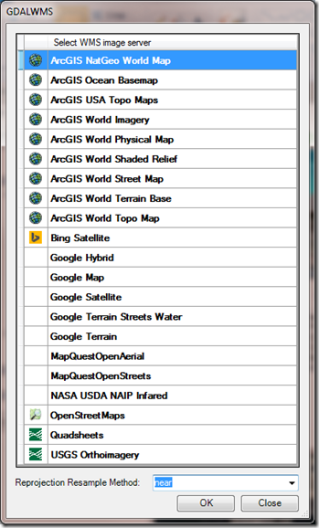
In RAS Mapper in 5.0 a new feature called Web Imagery is added. Web Imagery allows you to choose from 21 different web-based map types: Imagery, street maps, physical maps, topo maps, even infrared maps. You can select these background images right from the RAS Mapper and they are re-projected on the fly. These come from a variety of hosts like ArcGIS, Bing, Google, NASA, and the USGS. And each have worldwide coverage. Some of these maps/images will work well for you, some won’t, depending on the scale and location of your project. I have found that Google and Bing have excellent worldwide satellite coverage.
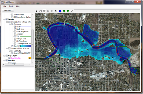
And here’s where it gets really cool: All of these maps and images are on the web, not your computer. Just like in Google Earth as you zoom out, different, and less detailed images are used, so that you are not unnecessarily downloading more detail than you need. As you zoom in, more detailed images are used so that you always have a nice crisp view. This is all done seamlessly and very quickly. And RAS only downloads what you need from the web for the current view extents you are at. Take the Muncie demonstration dataset that comes with HEC-RAS 5.0. I can zoom out to the full extent of the project and with Bing Satellite activated as my background image I have very nice coverage:

Now, I can also zoom in to a city block and have all the detail and precision I need.

By the way, the time it took RAS to redraw the inundation, download and clip the more detailed image, and reproject the new image was only 2.5 seconds on my computer.
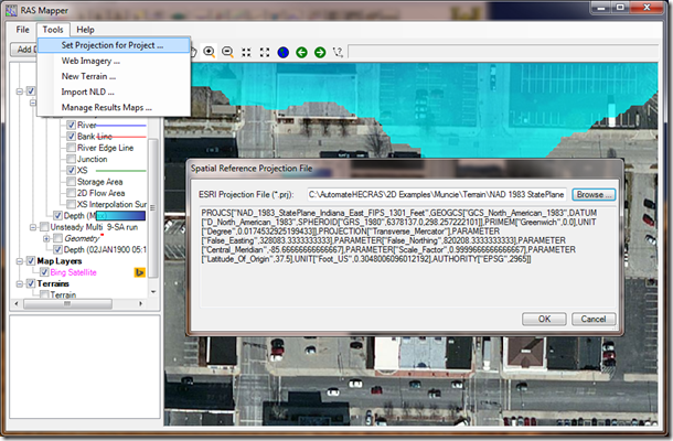
To access the web imagery in RAS Mapper, first make sure your model is projected to a recognized projection system. At the top of RAS Mapper, select Tools…Set Projection for Project…Here you’ll select a projection file (*.prj – NOT to be confused with a RAS project file!). If it’s a proper projection file, you’ll see the Metadata show up in the window below.

Once your model has a defined projection, you can add web imagery by right-clicking on Map Layers in the Layer Manager and selecting “Add Web Imagery layer…” or by selecting “Web Imagery…” from the Tools menu item. Once selected the following window will appear and you can choose any or all of the 21 available maps/images (you can only add one at a time though).

For most projects, you’ll probably be using Bing Satellite, ArcGIS World Imagery, Google Satellite, and perhaps some of the topo maps. The quality and usability of these different maps will depend on your location and viewing scale (as you zoom in closer and closer, some of the maps will no longer load).
Requirements for using Web Imagery in HEC-RAS 5.0:
1. Your RAS model must be set to a known projection.
2. You have to have internet access (high speed is obviously better).
For more information about Web Imagery in HEC-RAS Version 5.0, check out the document “Combined 1D and 2D Modeling with HEC-RAS”.
Get the lastest beta release of HEC-RAS Version 5.0 here.
Comments
Ross
on January 27, 2015Hi Chris. A RASMapper question for you. I finished a 2D model and am finalizing results. After reviewing the Depth grid I ran into issues processing the results. So I followed this tutorial (http://hec-ras-help.1091112.n5.nabble.com/Ras-Mapper-shapefile-export-td801.html) and I was able to export my results to create figures. The problem is the results of this new Depth grid using the Stored Raster" don't quite match the other Depth grid("Dynamic Surface" ). They use the same terrain. Any thoughts?
Chris Goodell
on January 27, 2015Ross- I'm not sure what would cause that. Other than the obvious:making sure the time stamp on the dynamic map is the same as the stored one, I can't say why they would be different. If you think it is a bug, try to document it as much as possible and sent to HEC (via their website) so they can fix it before the 5.0 release. Sorry I can't be of more help. Let me know if you solve the problem. Thanks.
Ross
on January 27, 2015I'm mapping the Maximum for both. Its certainly confusing. It is very subtle but noticeable.
Ross
on January 27, 2015I think I may have found a glitch– it seems to have to do with the flows entered on the grid. One appears to map them differently. See if you find the same thing.
lucas1867
on May 21, 2016I can't see those images in the geometric Data window, is there a way to put the background there? thanks
lucas1867
on May 21, 2016I can't see the background image in the geometric data window, is there a way to do so? thanks
Chris Goodell
on May 23, 2016Yes, but you have to have a projection and an associated terrain before it will work.
Anonymous
on July 8, 2016Can you explain how to do it?
Chris Goodell
on July 11, 20161. Add a projection in RAS Mapper.
2. Create a new terrain, or add an existing one.
3. Associate that terrain with the geometry file you want to use.
4. Add any other map layers you wish to have.
5. Go back to the geometry window and press the "Select Layers to view in Background" button.
6. Check the layers you wish to see.
7. Sometimes, you have to zoom in/zoom out or pan around or even close and reopen the geometry window before the layer(s) is/are added.
cgarner
on August 29, 2016I have the same issue and none of the solutions have worked for me. Is it possible this is a bug? I can't even get the Muncie terrain or image of terrain to load in the geometry window. Any suggestions? I poste dregarding my specific issue here:
http://hecrasmodel.blogspot.com/p/hec-ras-bloggery-forum.html
cgarner
on August 29, 2016I have the same issue and none of the solutions have worked for me. Is it possible this is a bug? I can't even get the Muncie terrain or image of terrain to load in the geometry window. Any suggestions?
http://hecrasmodel.blogspot.com/p/hec-ras-bloggery-forum.html
kimchau tran
on August 30, 2016I've done every steps above, but I can't see the layer I added. Can you explain?
kimchau tran
on August 30, 2016I can't see anything although I do all the steps above. Can you explain to me?
Chris Goodell
on September 6, 2016At the least, getting your image and terrain in the geometry window is quirky, at most it's a bug. Hopefully it will be fixed in the next version due out soon. Generally, when I've gone through all 7 steps above, if it's still not working, I'll double check that I've done all 7 steps correctlyt, then I'll try removing layers and re-adding them in RAS Mapper, closing and reopening HEC-RAS.
lucas1867
on September 7, 2016What worked for me is to check the Geometry Extents in Geometry > View > Set Schematic Plot Extents. Remember that the extents are initially based in the rivers and reaches drawn, and don't take into account the background image. So I imported the background extents from ArcGIS and was able to see it.
Hope it helps. Regards
seiha uksam
on October 11, 2016I had a problem with overlaying Google Satellite (G.S) and Terrain. The terrain doesn't display while the G.S is displaying. I'm working with OS WIN8.1
Chris Goodell
on October 12, 2016That is because the terrain is behind the satellite imagery. If you right-click on the Google Satellite layer, select image display properties, you can change the transparency.
krishna kumar
on November 18, 2016thanks for such a useful information.
i wish to do dam break analysis using HEC-RAS
here i dont have feasibility to get the hourly data regarding the rainfall can i use daily data instead of the hourly data for unsteady flow analysis in the analysis.
i was strucked at this point to start my project.
Unknown
on February 19, 2017Hi Chris
I am wondering if we need to have those terrain raster data so as to display those depth,velocity and WSE? Can't we do without it?
Chris Goodell
on February 22, 2017No, you need terrain data to map results.
Anna Firdaus
on April 25, 2017Hi Chris
I am interested in Ras Mapper software, and want to use it but I do not have it yet.
How do I get that software.
Thanks
Chris Goodell
on May 1, 2017RAS Mapper is part of HEC-RAS (Version 5 and newer). You can download the latest version (5.0.3) of HEC-RAS from the HEC website: http://www.hec.usace.army.mil
MOAZZAM ALI RIND
on May 14, 2017hy chris can you help me out to make a video clip of the results i got from my hec ras 5.0.3 2D Results like a animated flow as ras mapper show so that i may incorporate that in my presentation . as in 1d hec ras there is option to save the video but i am not able to find any option to do so in 2D. do you any have any experience about that ??
Chris Goodell
on May 14, 2017There is no option built into RAS Mapper for animating 2D results. However, you can use a screen capture program like SnagIt to make videos for you.
MOAZZAM ALI RIND
on May 15, 2017i have prepare a 2d model for indus lever lower reach of almost 250 km for my thesis and will be pleased to show u and receive your comment on that if u had some time and interest to do so. it will be my honor to do so
Chris Goodell
on May 15, 2017Moazzam- Congratulations on your thesis. I would be happy to look at your 2D model and thesis.
MOAZZAM ALI RIND
on May 15, 2017sure sir i will be sharing my model in a day or so . and regarding my complete thesis it is still under process and will be completing hopefully in last of this month or in start of next month so will be definitely sharing you after ward. right now i will be sharing my model in a day to have your comments sir.
MOAZZAM ALI RIND
on May 17, 2017hello sir i need your help regarding my work as i don't know why there is a unexpected error in my work now that all of sudden when i run my simulation on the same model now the simulation is not working i can't find the reason . although the simulation completes and show successful but when i see the results in mapper than it just shows me the result of a single day only the first starting day of simulation only and regarding other days the water disappears from the model nothing can be seen . do you have any suggestion on that i am quite worried for that now .
Chris Goodell
on May 17, 2017Try removing your results layer from RAS Mapper, recomputing and then reopening RAS Mapper.
Anonymous
on May 18, 2017Hello,
I have a visualization problem… When i want to change the geometry extent of my window in the "geometric data", it doesn't work: the coordinates remain unchanged. (I would like to have the extent of a picture make with the web imagery of RasMapper. My terrain is smaller than my picture)
Could you help me?
Sorry for my bad english…
Chris Goodell
on May 18, 2017In the geometry window, select View…Set Schematic Plot Extents. See if that works for you.
MOAZZAM ALI RIND
on May 18, 2017sir do you have any suggestion regarding setting of mesh size or its a thumb rule and on every one own choice?
Chris Goodell
on May 18, 2017A good rule of thumb is to have at least 5 to 7 cells across any conveyance areas you are interested in. You can use that to guide your mesh size selection.
Patricia
on January 12, 2018Hi Chris,
I can put a georeferenced image in the ras mapper model?. I have an image template area.
Chris Goodell
on January 15, 2018Yes, add it as a map layer in RAS Mapper.
L Johnston
on June 28, 2018Chris,
I'm working with data for Northern Ireland (Irish Grid EPSG 29901) and the web imagery layers don't line up with my terrain and river data (offset by about 75m). I've set the projection file in RAS mapper (PRJ file downloaded from spatialreference.org) and tried other similar Irish projections but with the same incorrect offset. The terrain data matches the river data fine. The same data matches up correctly with web imagery as wms layers in other software without problem (QGIS and Infoworks), and I have no idea how to troubleshoot this as the problems seems to be only in Hec RAS. Any ideas appreciated, thanks.
pensil
on July 5, 2018Hi Chris, I try to using web imagery. after selected google hybrid as the web imagery, i got an error that mentioned "error loading image from file: …. to POJ.4 format is know". can you give me a guideline or an idea to solve this problem. Thanks.
hala serhan
on July 16, 2018hi, can some one help in HEC ras 5.00? please.. im facing a trouble in the RAS mapper with the results the depth of water in the wadi is not showing although i have run the model without ant errors? any thoughts?
sss
on October 2, 2018Hi chris,
I am on a flood inundation mapping work and in symbology my depths vary from 0 to 6m.. I want to remove the areas where the flow depth is less than 0.3m as those areas are not very harmful.. But in symbology I cannot find any thing like no color..Any idea???
Secondly say we are doing a flood analysis for a periode of 10 days with precipitation.. Is there any method available to show the infiltration or evaporation after the rain.. My problem is when it rains isolated lowland areas are flooded but those water will remain with the same depth until the simulation ends.. Any idea??
Thank you very much chris for the good work.. Greetings from Sri Lanka.. I am big fan of you following this blog from 2013..
Chris Goodell
on October 3, 2018In RAS Mapper, under Tools, options, you can select render mode and in there specify a threshold depth for display. Currently there is not a way to simulate infiltration after rainfall. That may be added for the next version.
Meenal
on December 13, 2018Hi Chris, recently i have issue with ras mapper. i am unable to set projection for project and later able to create new ras terrain. Before i was able to add and later able to run my project. Even i have try with 5.0.5, 5.0.4 version in 3 different pcs also but no luck.
Thank you,
Regards,
Meenal Dave
Unknown
on February 23, 2019How to add base map in hec ras?
Add Your Comment